The nondescript lowlands surrounding the Old River Control Structure – the complex of levees, dams, floodgates, and spillways designed to prevent the great Mississippi River from changing course into the Atchafalaya – belie a fascinating history of man subjugating nature and nature’s inevitable payback.
Centuries ago, the Mississippi meandered westward at Turnbull Bend to capture the Great-Raft-choked Red River. Then, came the settlers, the steamboats, and Captain Henry Miller Shreve, who, in the name of expediency, demolished the ancient logjams and cut through twenty-mile-long Turnbull at its neck. Deprived of current, the upper “Old River” bend silted up, and the uncorked Red once again drained into its ancient downstream channel, the Atchafalaya. As the years passed, the Atchafalaya deepened and began to siphon the Mississippi’s water through the lower bend. If left unchecked, the switchover would continue, so engineers built the Control Structure to defeat gravity and maintain a 70-30% split of the flow.
You can learn more from Randall Munroe’s excellent summary. And, for additional maps and details of the catastrophe which would befall New Orleans should its lifeblood Mississippi turn away – loss of fresh drinking water, mud-clogged shipping channels, destruction of barrier swamps, and more – see the Wetland Resource Center’s river control page.
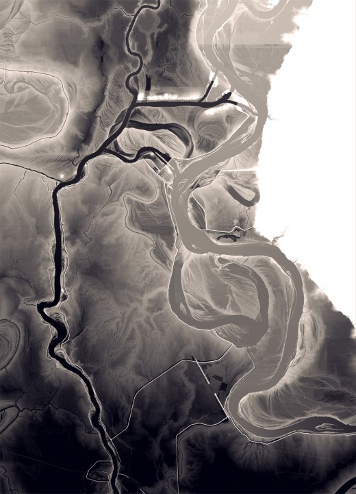
Just how close is the Atchafalaya to capturing the Mississippi, in geographical terms? To get a feel, I downloaded the USGS digital elevation data and made a map to accentuate the ups and downs of the local terrain. Here’s the immediate area, roughly 25×35 miles, colored by surface height, less than 25 feet above sea level (ASL) in black, more than 55 feet ASL in white, with intermediate greys representing the elevations between:
The Mississippi runs down the right side, and the Red and Atchafalaya are the north-south rivers on the left. On this map, each is at the approximate height of a typical spring flow. At top center, we see the Old River Control system and its branching east-west connector channel. The gap in the linear levee west and just before the last turn of the Mississippi is the Morganza Spillway.
At equal latitude, the Mississippi runs across a narrow terrace of land, much higher than the neighboring Atchafalaya. In many spots, at flood stage, a single levee appears to be the only barrier between the two – a fact that should have even the most Katrina-jaded New Orleanian sweating beads. As Mark Twain once said:
One who knows the Mississippi, will promptly aver – not aloud, but to himself – that ten thousand River Commissions, with the mines of the world at their back cannot tame that lawless stream, cannot curb it or confine it, cannot say to it, Go here, or Go there, and make it obey; cannot save a shore which it has sentenced; cannot bar its path with an obstruction which it will not tear down, dance over, and laugh at.
In other words, if Mardi Gras is on your bucket list, y’all best roll down to the Big Easy and get your freak on while the gettin’s good, y’hear?
